Startrails over Cerro Tronador, Patagonia 27 Mar 2013 7:26 AM (12 years ago)
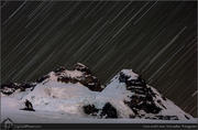
Here is a shot that took about one hour to prepare (not including the 6 hr drive and 5 hr hike/ski :) and 16 minutes to take. This is Cerro Tronador, an extinct volcano (though the area is still quite active) of 3400m/11,000ft. It sticks 1500m /5000ft above all neighbouring mountains and is covered in huge glaciers with thousands of crevasses (check Google Earth!).
I wanted to use my 135mm 2.0 lens for a long exposure to see how that would work out, but the preparation was a nightmare. There was no moon and the stars on this side were not bright, so live preview did not work when focusing on the pitch dark mountain. Even if I focused on the brightest star, the mountain would be out of focus at F2.0.
The depth of field is so limited (and it has the best bokeh ever) on this lens that even at a long distance it is difficult to get everything in focus. Infinity is never infinity at all (or maybe it is, but the mountain was closer than infinity) and even a slight tap on the lens would change the focus distance when at 2.0.
So in the end I had to stop to F5.6 to make my life outside on the glacier a bit more bearable and get the mountain as well as some stars in focus :)
Of course, this had the added problem of needing more time, but the added benefit of longer star trails. Instead of taking a series, I only took one image, 16 minutes, ISO 800, F5.6…
Related photos:


Surinam family in French Guyana 22 Mar 2013 7:28 AM (12 years ago)

During the civil/jungle war in Surinam in the 1980’s many people fled to neighbouring French Giuana. Only the mother of this family still speaks a bit of Dutch, the kids never learnt it.
This friendly bunch took us into their homes for the night even giving us a place to sleep and food to eat, while our bikes were parked in the kitchen! So many nice and good people we met while cycling the Americas, don’t believe the hype and see the world…
Porters on Baltoro Glacier with K2 in back 17 Mar 2013 7:18 AM (12 years ago)
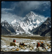
Taken at the Baltoro glacier crossroads, a group of porters are taking a break while K2 is standing proud at the horizon…
————-
I am using my photography to promote our Solar light project, replacing toxic kerosene lights by solar-powered LED lights. Please see http://flexiwaysolar.com for more info and get your own lights as well (delivery now worldwide!)
*********
K2 (also known as Chhogori/Qogir, Ketu/Kechu, Savage Mountain, Mount Godwin-Austen) is the second-highest mountain on Earth, after Mount Everest. With a peak elevation of 8,611 m (28,251 feet), K2 is part of the Karakoram Range, and is located on the border between Baltistan, in the Gilgit–Baltistan region of Pakistan, and the Taxkorgan Tajik Autonomous County of Xinjiang, China.
The name comes from *K*arakoram, it was simply the 2nd peak identified during a survey of the range. Though K1 has been renamed to Masherbrum, the local name, experts are still not out if K2 actually has a local name as it cannot be seen from any inhabited place, you have to hike for days up the ginormous Baltoro Glacier to even see it, but when you do, you might want to sit down for a moment…
Shot on slide in 2004, scanned in 2012.
Related photos:
Sunrise from Vallenaraju, Peru 10 Mar 2013 6:51 AM (12 years ago)
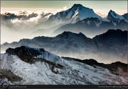
Cordillera Blanca, Peru, at dawn.
Related photos:
Ojos de Caburga, Chile, Patagonia 5 Mar 2013 5:46 AM (12 years ago)
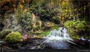
This was shot in a wonderful place in Chilean Northern Patagonia, and is called the Ojos de Caburga (Ojos=Eyes in Spanish, Caburga is the name of the nearby town.) I don’t do much HDR normally, but I thought this would be suitable.
It is a wonderful set of waterfalls, ending up in the same pool before continuing as a river. Camping here with friends, guitar, food and drink is wonderful :)
Related photos:
Mount Fitzroy from Laguna de Los Tres, Argentina, Patagonia 28 Feb 2013 5:44 AM (12 years ago)
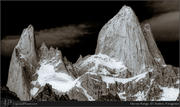
I am slowly going through my many shots from a recent Patagonia trip. Here is a iconic shot from El Chalten, better known as Mount Fitzroy (El Chalten is still the name of the nearby town).
I hiked up late in the afternoon and bivouacked the night at the Laguna de los Tres, so I could be there in time for the sunrise. It’s a wonderful vista, more to come…
Though normally the mountains are hidden in clouds, it was actually really clear, so I added a bit of drama using HDR & Orton and B/W :)
Related photos:
Mount Fitzroy from Laguna de Los Tres, Patagonia 24 Feb 2013 5:41 AM (12 years ago)
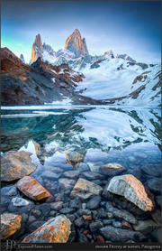
I am slowly going through my many shots from a recent Patagonia trip. Here is a iconic shot from El Chalten, better known as Mount Fitzroy (El Chalten is still the name of the nearby town).
I hiked up late in the afternoon and bivouacked the night at the Laguna de los Tres, so I could be there in time for the sunrise. It’s a wonderful vista, more to come…
Related photos:
Iceberg near Grey Glacier, Patagonia 17 Feb 2013 5:17 AM (12 years ago)
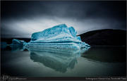
It’s #sciencesunday ! Glaciar Grey is a huge glacier in the Torres del Paine National Park. As the glacier is moving and ends in a body of water, parts break off and form icebergs like the one above. It is impressive to carefully boat around these, as normally around 89% is hidden beneath the surface…
What is an iceberg? From WikiPedia:
“An iceberg is a large piece of freshwater ice that has broken off a glacier or an ice shelf and is floating freely in open water. It may subsequently become frozen into pack ice (one form of sea ice). As it drifts into shallower waters, it may come into contact with the seabed, a process referred to as seabed gouging by ice.
The word “iceberg” is a partial loan translation from Dutch ijsberg, literally meaning ice mountain, cognate to Danish Isbjerg, German Eisberg, Low Saxon Iesbarg .
Because the density of pure ice is about 920 kg/m³, and that of sea water about 1025 kg/m³, typically only one-ninth of the volume of an iceberg is above water. The shape of the underwater portion can be difficult to judge by looking at the portion above the surface. This has led to the expression “tip of the iceberg”, for a problem or difficulty that is only a small manifestation of a larger problem.
Icebergs generally range from 1 to 75 metres (3.3 to 246 ft) above sea level and weigh 100,000 to 200,000 metric tons (110,000 to 220,000 short tons). The largest known iceberg in the North Atlantic was 168 metres (551 ft) above sea level, reported by the USCG icebreaker East Wind in 1958, making it the height of a 55-story building.”
Related photos:
Sunrise from Chimborazo, Ecuador 15 Feb 2012 6:22 AM (13 years ago)
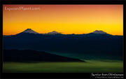
This image was shot in the early morning at the point farthest away from the center of the earth -> Mt Chimborazo in Ecuador, just before sunrise.
The mighty glacier-covered volcanoes Cotopaxi, Cayambe & Antisana can be seen on the horizon…
————–
(I am using my photography to get attention for my project that will help fight global warming, deforestation and poverty. Please check out http://flexiwaysolar.com to order and/or donate a Solar-powered LED lamp, or support us by re-sharing)
————-
Related photos:
Makalu from Mount Everest after sunrise 11 Dec 2011 11:02 PM (13 years ago)
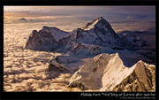
One of my most popular images on ExposedPlanet is the image of Makalu at sunrise, taken from the 3rd step of Everest. Makalu is the 5th highest mountain on earth, so there are not too many places from where you can look down on it.
I had taken a second image, a while later and had never edited it well, so now is the first time I am sharing this later picture. The original was shot just before the sun came up, this one just after. The light is different, the image is sharper and features of Mt Makalu are clearer. Though the other image is dreamier, I might even like this twin image better, how about you?
Related photos: