Bostonography - bostonography.com - Bostonography
General Information:
Latest News:
Mapping Hubway availability 23 Jul 2013 | 11:53 pm
As an occasional Hubway user, I sometimes feel like some kind of transportation gambler. There’s a risk with each trip. Will docks be available where I’m going? Will bikes be available when I want to ...
Neighborhoods as seen by the people 27 Jun 2013 | 09:56 am
Below is a map that has been shown off a bit recently, both on Twitter and by me at a couple of events this month (namely, at a Boston Indicators Project open house and in the related Data Day also or...
Live MBTA bus speeds 30 May 2013 | 08:18 pm
‘Tis the season to revisit and update some of our past projects. You may remember the map from November 2011 showing 24 hours of GPS location data from MBTA buses, colored according to their speeds. (...
A plow, now! 15 Feb 2013 | 08:34 pm
Remember that time last weekend when it snowed a whole bunch and we all waded through four-foot drifts to get out of the house, went skiing down city streets, or else enjoyed lots of bacon and beer in...
Bostonhenge 8 Jan 2013 | 08:33 pm
New Yorkers want to own everything. Even the sunset once in a while: you may have heard of the phenomenon known as Manhattanhenge, when the setting sun aligns with Manhattan cross streets. It occurs t...
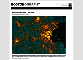
Blue and Bluer: Massachusetts and Boston 2012 14 Dec 2012 | 09:39 pm
You’ve seen tables and maps of counties and towns with the numbers for President Obama and Governor Romney in November’s election. But you may not have seen the detailed story in Boston. Well, that’s ...
Handy turkey maps of Boston 22 Nov 2012 | 12:48 am
(Or, “Bostonography goes back to kindergarten.”) This town is no stranger to turkeys. Above is a rude, slow pedestrian near Harvard Square, for example. Wait, maybe Harvard Square is a turkey! We trie...
Visualizing Hubway, for real this time 6 Nov 2012 | 12:58 am
How convenient. As soon as we got around to our previous post, in which we mapped some Hubway bike sharing data, a new visualization contest started. This time, MAPC and Hubway invited people to visua...
MBTA + Boston Bikes Visualization 4 Oct 2012 | 10:37 pm
Back in January, the MBTA and City of Boston sponsored a developer challenge to develop new apps and visualizations making use of real-time bus locations and Hubway bike sharing station data. For the ...
Street, Road, and Avenue 4 Sep 2012 | 06:02 pm
Our friend Derek Watkins recently made a map which he claimed copied something I once did (although he did it much more beautifully), so why don’t we return the favor? He also made a few other maps of...